


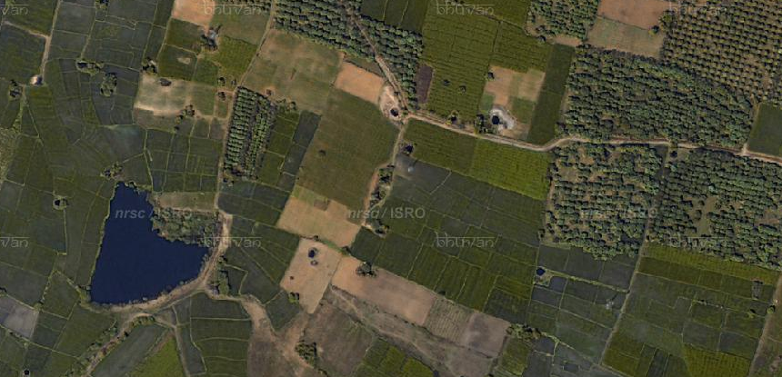
Satellite image of agricultural land in Karimnagar, Telangana (Credit: Bhuvan, ISRO)
Indian Farmer Suicides: An ongoing crisis
One of the heartbreaking crises that India faces is farmer suicides due to myriad reasons including a failed harvest, drought, lack of proper irrigation, crop disease, steep fall in crop prices, and inability to pay back modest loans.
In 2015, farmer suicides rose by over 40% compared to the previous year [1]. While 2014 saw 5,650 farmer suicides, the figure crossed 8,000 in 2015, according to government sources. Maharashtra led the tally with an 18% jump from 2,568 to 3,030, followed by Telangana that recorded over 1,350 farmer suicides, up from 898. The state that came in 3rd was Karnataka. What was worse is that Karnataka registered the sharpest jump from 321 to more than 1,300. While the countrywide toll for 2016 is yet to be published, in the first 4 months alone, it reached 1,548, 92 more than in 2015 during the same period. In Marathwada alone, the number crossed 400 [2].
Problem of precipitous fall in crop prices
As it is, the farmers don’t get much for the love and labor they put into cultivating crops that the country consumer. It is usually the middlemen and the retail businesses that make the most profit. Things get worse when the prices go into a nosedive.
Traders attribute the price fall to glut. In the absence of a statutory body to regulate the prices of perishable and nonperishable crops, stakeholders like government bodies, farmers, traders, fertilizer manufacturers, etc require visibility into crop output and price forecast to take effective decisions.
Leveraging satellite technology for better price forecasting
To ensure better price forecasting by agriculture stakeholders, Earth2Orbit Analytix is “leveraging satellite imagery, ancillary data, ground truth and machine learning algorithms”.
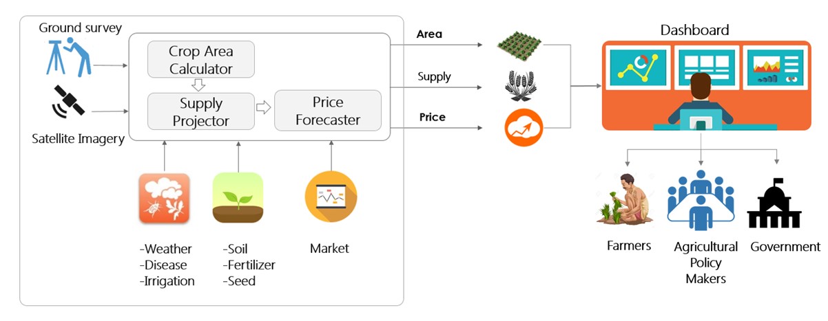
AgriFore from Earth2Orbit Analytix
AgriFore from Earth2Orbit Analytix includes 3 models that cumulatively form a price forecasting tool that can be used by government and private price forecasting entities.
AgriFore from Earth2Orbit Analytix
AgriFore from Earth2Orbit Analytix
1.Crop Area Calculation Model This is a crucial input both for the supply projections and price forecasting models. This model leverages satellite data to accurately calculate area under cultivation for different crops. Current techniques used to estimate area under cultivation are manual and highly inaccurate.
2.Supply Projection Model Crucial tool for governmental agencies to plan interventions to ensure proper pricing and adequate supply e.g. plan and execute futures contracts for crop prices, crop import and export at a state-level.
3.Price Forecasting Model Helps farmers in determining the right choice of crops and to take corrective measures mid-season if the choice of crops cultivated don’t work out.
Earth2Orbit Analytix and Indian Institute of Management, Bangalore are collaborating in developing these models.
About Earth2Orbit Analytix
Earth2Orbit (E2O) Analytix, a Bangalore based start-up creates GeoIntelligence data products that leverage satellite imagery to provide location specific commercial, economic, environmental and social intelligence in a cost-effective manner.
E2O Analytix leverages composite data sets, sophisticated algorithms and advances in “Big Data, Deep Learning, and Cloud Compute” to respond to pressing social, business and environmental questions and concerns. It combines Earth Observation (EO) data with large volumes of ancillary data to deliver "actionable intelligence" to clients. The clients are from a variety of sectors including, but not limited to agriculture, environment, insurance, infrastructure and cities.
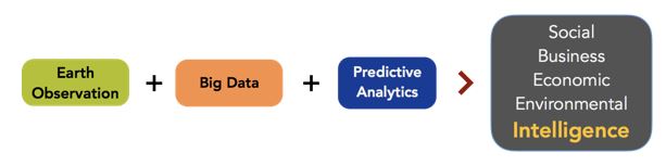
As satellites cover large swaths of Earth, E2O’s platform generate GeoIntelligence for large areas very quickly. The intelligence can be Global, Regional, Local or Hyper-Local. The intelligence includes patterns, correlations and provides insights into economic indicators, market trends, macro-level changes and customer behavior.
Earth2Orbit Analytix has access to experts in space agencies such as Indian Space Research Organization (ISRO), Centre National d'Etudes Spatiales (CNES), National Aeronautics and Space Administration (NASA), European Space Agency (ESA) and Japan Aerospace Exploration Agency (JAXA). Earth2Orbit Analytix is partnering with premier academic institutions such as Indian Institute of Management (IIM) - Bangalore and Indian Institute of Science (IISc), Bangalore. Earth2Orbit Analytix also has relationships with satellite companies worldwide and can source imagery from international EO constellations such as DigitalGlobe, Airbus, Planet, etc..
Applications of Earth2Orbit Analytix GeoIntelligence
GeoIntelligence finds applications in multiple sectors such as:
Agriculture, Insurance, Financial Services, Shipping, Mining, Smart Cities, Oil & Gas, Cargo & Logistics, Infrastructure, Retail and Aviation.
Within the Agriculture sector Earth2Orbit Analytix provides location-specific geointelligence on:
1.Vegetation analysis
2.Crop health
3.Land use management
4.Crop acreage
5.Production estimation
6.Drought assessment & monitoring
7.Soil mapping
8.Salinity and Alkalinity mapping
9.Waterlogging
10Irrigation management
11.Foreign object encroachment
12.Flood plain monitoring
References
[1]http://indianexpress.com/article/india/india-news-india/farmer-suicide-case-in-india-crop-failure-drought-dry-zones-indian-monsoon-2984125/, as viewed on 10 March 2017
[2]http://indianexpress.com/article/india/india-news-india/farmer-suicide-marathwada-drought-maharashtra-2805116/, as viewed on 10 March 2017
Earth2Orbit Analytix
Bangalore
राबतो:
Mr. Amardeep Sibia
CTO & Co-Founder
Phone: +91-7760984777
इ-मेल: amardeep@earth2orbit.com